Deer Collisions Database’ ( www.deercollisions.co.uk ) - Update March 2004
Dear All,
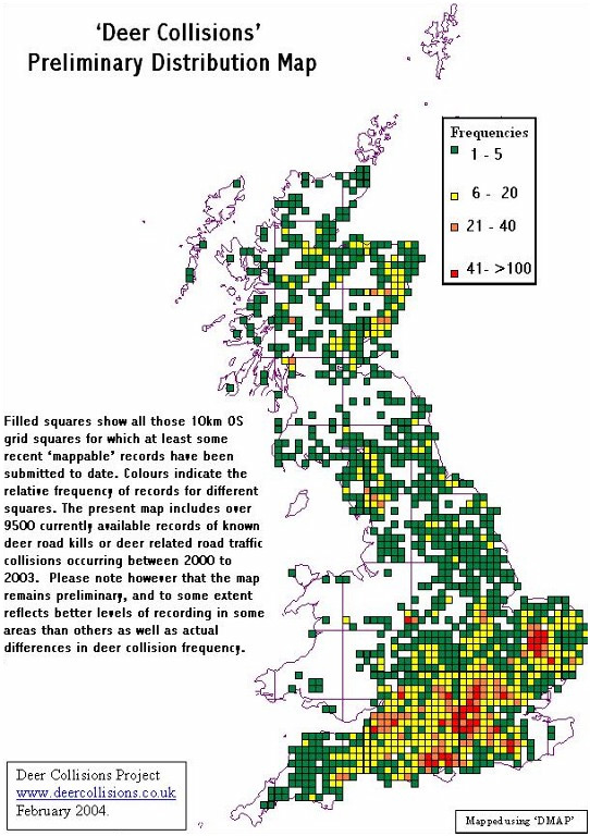
The Deer Collisions Project has been underway for twelve months now, with at least one further full year of recording planned at present. However, thanks to all of you, we have already been able to collate and map close to 10,000 records of deer road kills and deer related road traffic collisions which have occurred since January 2000.
A preliminary map showing the distribution and approximate numbers of those records which we have so far managed to enter into the database is appended below for your interest. Please be aware that this overview remains incomplete and there are many further records which have been submitted but which still need to be properly grid-referenced and entered into the main database. Nevertheless, the present map already confirms just how widespread a problem – both in terms of animal welfare and road safety - deer-vehicle collisions are throughout the Britain. Even with only an incomplete set of human injury accident data for last year, it is clear that in addition to the many thousands of deer killed or injured annually, such collisions also led to well over 250 personal injury accidents, including at least 8 fatal crashes involving deer during 2003. The annual cost of car repairs, over and above human injury costs, is estimated to have exceeded £11 million.
The initial twelve months of this two year project had been planned largely for us to set-up and publicise the study, and get our data collection networks established, and we recognised that in the early stages we would not necessarily get the fullest datasets that we hope will eventually be possible. Indeed, as expected entries of records via the web-site continued to increase gradually throughout that first year. As the year progressed, we were also able to recruit help from more and more Regional Police Forces, Council Road Safety Departments, Trunk Road Agents and Council Road Cleansing Operators (responsible for clearing carcases from the roadside), RSPCA / SSPCA and other animal welfare organisations, Forestry Commission, countryside rangers, deer stalkers, vets and many others who are called out to deal with dead or injured deer. As a result, we hope to be able to obtain much more comprehensive reporting during 2004 - So please do keep your records coming.
While the enclosed map summarises preliminary results at the low resolution of 10km squares, many records received can already be mapped much more closely to within 1km or even 100 metres or better. These more precisely located records will be particularly valuable during the next stage of analysis to help us to identify locations (e.g. 1 km squares or shorter road sections) with the highest deer collision risk, and where improved mitigation might best be targeted in future. They will also enable assessment of the key factors which appear to affect accident risk, including things like road type (single or dual carriageway, motorway), road side habitat, existing mitigation measures (such as fencing, roadside reflectors, warning signs), whether the road is straight or twisty, and so on. We would therefore be most grateful if all contributors could, whenever possible, provide as much information as is available to help us pinpoint and map records accurately. OS grid references are ideal for this (remembering always to give Easting before Northing to avoid too many deer collisions being logged in the sea!). However, if no Ordnance Survey map is to hand, a simple description of the location would be appreciated (which, for those submitting directly to the website, can be entered as text in the 'nearest village' field on the form; even without a grid reference, a brief statement "2 miles west of xxx on the such-and-such road " usually enables more accurate mapping than the mention of a village name alone.
Whether you are submitting directly to the project website or to one of us (by email or conventional mail), please also remember that you are not necessarily expected to fill in every field of the incident report forms we have provided! Please don’t be put off if you cannot answer all the questions - these are simply provided to allow full details to be recorded if they are available. We wish to log as high a proportion of all deer collisions as we can, even if records are not always ‘perfect in every detail’. The minimum we do require is the date (either of the incident or when the deer was found), the road number and an approximate location. If you can tell us more, about the species of deer, roadside habitat, time of day, mitigation measures … so much the better; but if you cannot, please simply complete as much as you can. Please remember too, that we are not just interested in records of incidents you yourself may have had the misfortune to become involved in: we would be grateful for details of accidents you have observed, or simply of carcases seen by the roadside. We have procedures in place to identify duplicate records, so don’t worry (or assume) that someone else will already have reported it: the chances are they haven’t. At present we are probably still capturing information on merely around 10% -20% of all deer road kills, with only low numbers of possible duplicate records being received.
While we are not happy about the large number of accidents we seem to be unearthing (to take one example, during 2003 more than 300 deer carcases were uplifted by the Council from the roads in Aberdeenshire alone), we are really pleased with the response we’ve had from Councils, Roads Agencies, the Police, other organisations and the general public, and that at least we are now able to make some start on trying to establish a fuller picture of the problem of deer-vehicle accidents nationwide. But as we note, 2003 was the set up year: with more and more people now on board, the first really full year’s collection of data is set to start. We will be continuing to collect records throughout 2004 , and hopefully well into 2005.
Thank you for your continued support of this project, and we look forward to receiving more information from you in the coming year. If you require more recording forms or posters please do contact any of the team members. [Jochen Langbein or Dave Hooton for England and Wales; Rory Putman for Scotland]
Yours sincerely,
Dr. Jochen Langbein - Tel. 01984 641366 or email deer@langbein.freeserve.co.uk or info@deercollisions.co.uk
David Hooton - Tel. 01842 890798 or email eastern@thedeerinitiative.co.uk
Prof. Rory Putman - Tel. 01967 421304 or email rjputman@deercollisions.co.uk
Postal address:
“Deer Collisions Project”, PO Box 465, Bury St Edmunds, IP28 6XD.
This project is administered by The Deer Initiative on behalf of the Highways Agency and Scottish Executive. We should like to acknowledge the financial support of this project so far by The Highways Agency, The Scottish Executive, National Forest Company, Woodland Trust, and The Deer Study & Resource Centre, as well as the help and support being provided by all other partner organisations making up The Deer Initiative in England and Wales and The Deer Commission for Scotland.